


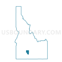
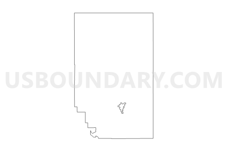
Voting District 3, Gooding County, Idaho
About
Outline

Summary
| Unique Area Identifier | 564083 |
| Name | Voting District 3 |
| County | Gooding County |
| State | Idaho |
| Area (square miles) | 345.18 |
| Land Area (square miles) | 343.94 |
| Water Area (square miles) | 1.24 |
| % of Land Area | 99.64 |
| % of Water Area | 0.36 |
| Latitude of the Internal Point | 43.02145130 |
| Longtitude of the Internal Point | -114.74010000 |
Maps


Graphs
Select a template below for downloading or customizing gragh for Voting District 3, Gooding County, Idaho


Neighbors
Neighoring Voting District (by Name) Neighboring Voting District on the Map
- Voting District 025001, Camas County, ID
- Voting District 025002, Camas County, ID
- Voting District 063001, Lincoln County, ID
- Voting District 063002, Lincoln County, ID
- Voting District 063003, Lincoln County, ID
- Voting District 1, Gooding County, ID
- Voting District 2, Gooding County, ID
- Voting District 5, Gooding County, ID
- Voting District 6, Gooding County, ID
- Voting District 7, Gooding County, ID
- Shepherd Voting District, Jerome County, ID
Top 10 Neighboring County Subdivision (by Population) Neighboring County Subdivision on the Map
- Jerome CCD, Jerome County, ID (19,206)
- Gooding CCD, Gooding County, ID (6,392)
- Shoshone CCD, Lincoln County, ID (4,059)
- Bliss CCD, Gooding County, ID (1,082)
- West Camas CCD, Camas County, ID (747)
- East Camas CCD, Camas County, ID (370)
Top 10 Neighboring Place (by Population) Neighboring Place on the Map
Top 10 Neighboring Unified School District (by Population) Neighboring Unified School District on the Map
- Jerome Joint School District 261, ID (19,389)
- Gooding Joint School District 231, ID (6,805)
- Wendell School District 232, ID (5,436)
- Shoshone Joint School District 312, ID (3,128)
- Hagerman Joint School District 233, ID (2,433)
- Camas County School District 121, ID (1,117)
- Bliss Joint School District 234, ID (749)
Top 10 Neighboring State Legislative District Lower Chamber (by Population) Neighboring State Legislative District Lower Chamber on the Map
Top 10 Neighboring State Legislative District Upper Chamber (by Population) Neighboring State Legislative District Upper Chamber on the Map
Top 10 Neighboring 111th Congressional District (by Population) Neighboring 111th Congressional District on the Map
Top 10 Neighboring Census Tract (by Population) Neighboring Census Tract on the Map
- Census Tract 9601, Gooding County, ID (7,474)
- Census Tract 9501, Lincoln County, ID (5,208)
- Census Tract 9702, Jerome County, ID (4,184)
- Census Tract 9701, Camas County, ID (1,117)
Top 10 Neighboring 5-Digit ZIP Code Tabulation Area (by Population) Neighboring 5-Digit ZIP Code Tabulation Area on the Map
- 83338, ID (19,782)
- 83330, ID (6,599)
- 83352, ID (3,330)
- 83327, ID (970)
- 83314, ID (898)
- 83337, ID (33)